
Model Maker Systems was founded in 1989 to market software commercially, having begun developing software in 1982. Our staff are constantly looking to the horizon and pride themselves on products that exist at the industry’s cutting edge.
Model Maker Systems provides software for technical surveying, land surveying, engineering, mining, town planning, landscaping, quantity surveying, irrigation design, and construction. Our software is currently used by more than 4,300 clients across 98 countries.
Model Maker Systems’ vision has always been to put our clients’ needs and experience first. We achieve this through –
- offering excellent software and support services at affordable prices,
- our marketing policy based on fair pricing and outstanding support,
- developing our software in line with user requests.
Our products are developed by experts who work in the industry, then further refined based on user feedback with the aim of improving the user experience.
Model Maker: Fully integrated land survey and engineering design software
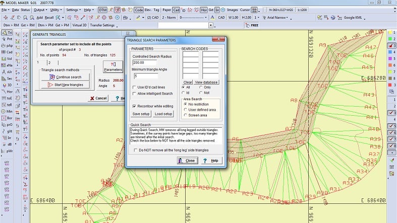
The most advanced product in Model Maker Systems’ software suite, Model Maker is an intuitive, fully integrated digital terrain modelling programme. Originally launched with the purpose of reducing tachometric survey data to x, y and z coordinates, today the software boasts some of the most advanced functions available in terrain modelling and computer aided design.
Model Maker lets users input data manually using any survey method, importing data from electronic data recorders or GPS systems, as well as from fixed or free-format ASCII files. The programme’s built-in digitising option also allows it to capture data from existing drawings.
Model Maker features a complete integrated CAD link between survey data and drawing functions, allowing the design engineer or surveyor to create detailed drawings efficiently on screen with the survey active in the background. Users can create new line styles and symbols for use on drawings, in addition to the line styles that are already available.
Road maker: Intuitive software for the design of roads
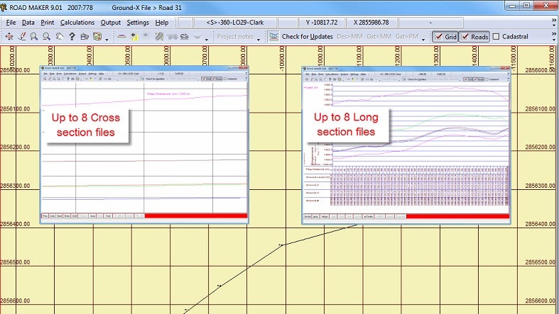
Model Maker Systems’ Road Maker is a roads programme designed to meet the needs of design engineers and contractors. Users can import data from tacheometric surveys within Model Maker or type them in manually.
Road Maker defines the vertical alignment and road cross-sectional profile using intuitive built-in functions. Users can calculate volumes between a ground cross-section group and the design profile, or between two ground cross-section groups. The final cross-section and any long-section drawings can be plotted directly to a plotter or various CAD data exchange ASCII formats.
The programme allows users to obtain comprehensive setting-out information for setting out the design on-site, such as layer profiles and batter boards. It can convert the design profile or ground cross-sections into DTM format so they can be further manipulated with Model Maker.
Pipe maker: Fully equipped software for designing and building pipelines
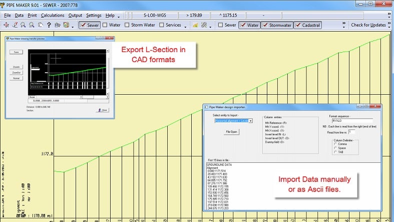
Model Maker Systems’ Pipe Maker offers a comprehensive solution for designing and constructing sewer, stormwater and water pipe projects. The programme’s design options enable the creation of long sections for the design of pipelines, while users can extract ground long-section data from tacheometric survey data using Model Maker or input it manually.
Pipe Maker includes all the input data required for the design of water, stormwater or sewer pipes. The programme calculates earthworks and pipe quantities in line with SABS 1200 specifications and allows results to be output to a file or printer. It also enables long-sectional drawings to be plotted directly to a plotter or one of several CAD data exchange formats.
Survey Maker: Software applications to meet surveyors’ needs
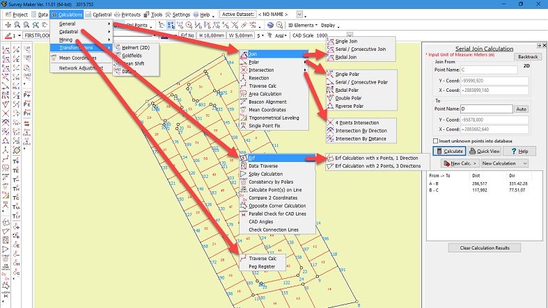
Survey Maker is a programme designed for the survey field, featuring solutions for the engineering surveyor, land surveyor, geodetic surveyor, surface and underground mining surveyor, and hydro-surveyor.
Survey Maker allows users to enter data via several methods, from Model Maker files to electronic field books, then input it manually into the calculation pages. All correction factors are used, as well as limits of error calculations where necessary.
Irri Maker: One-stop software for irrigation system designers
Model Maker Systems’ Irri Maker is a one-stop solution for irrigation system designers. As a digital terrain modelling (DTM) software package, it is well-known and widely used worldwide in the fields of land survey, engineering, mining and construction.
Since its design began in 1992, Irri Maker has been continuously updated to meet industry demands and comply with the latest computer technology. The programme operates independent of other commercial software and includes its own plotting and reporting capabilities.
This module will assist the irrigation design engineer with a flexible and indispensable tool without confining him to rigid limitations. Full graphical control over the automatic and manual design of an irrigation network is provided. Analysing the hydraulics of an open network with predefined or computer selected pipe sizes is done with ease.
Global manipulation of groups of pipes and nodes may be done to optimise the design. Standard pipes, emitters and fittings may be defined in a user database. Model Maker DTM and CAD functions are available throughout the design. Design drawings and installation parts lists can be extracted.
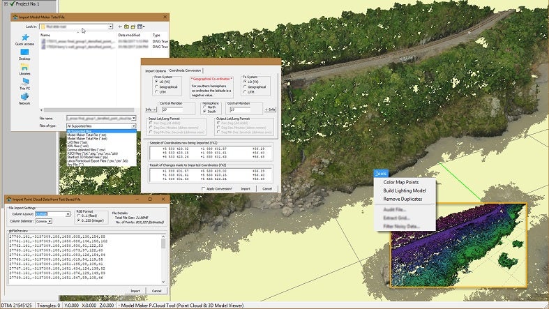
Point cloud viewer: Post-processing software for converting modelling data
Point Cloud Viewer is Model Maker Systems’ post-processing software package. Its simplicity and power allows users to convert X, Y and Z points from scanning equipment to a workable format with ease.
Point Cloud Viewer can handle millions of points easily and import them into Model Maker so that normal modelling can be carried out. The programme includes a virtual survey module that can extract data for use in Model Maker or another DTM software package, as well as a module to remove noise and audit data through the use of classification or user-defined parameters.